TrackLab
Model: NLTL
We all use location systems in our everyday lives, varying from navigation systems to GPS trackers. The abundance of location and tracking systems offers you an immense amount of data at low cost. But how do you use this data in professional applications or research projects? How do you extract meaningful infor-mation from this data? How do you enable other systems to interact with the data? We now have the solution that answers all of these questions: TrackLab.
Whether you work on consumer behavior research, visitor be-havior studies, spatial cognition, behavioral ecology, wildlife or farm animals, TrackLab will aid you in your work. It is compatible with various indoor and outdoor tracking systems, such as GPS, Ultra Wide Band, video tracking or stereo camera sensors.
TrackLab is our new software tool for recognition and analysis of spatial behavior and the design of interactive systems. It allows you to work with any number of subjects, in any spatial context, tracked by any type of positioning system. Taking advantage of our 25 years experience in trajectory analysis and the increasing availability of different tracking technologies, TrackLab is the versatile workbench for all your studies on movement and location.
TrackLab will aid you in the complete process of your work on spatial behavior. After you decide on the tracking system most suitable for your work, TrackLab lets you import the collected tracking data real-time as well as offline. The collected data can be visualized, processed and analyzed. Furthermore, you can create interactive systems based on the generated data, which is available real-time.
Real time feedback
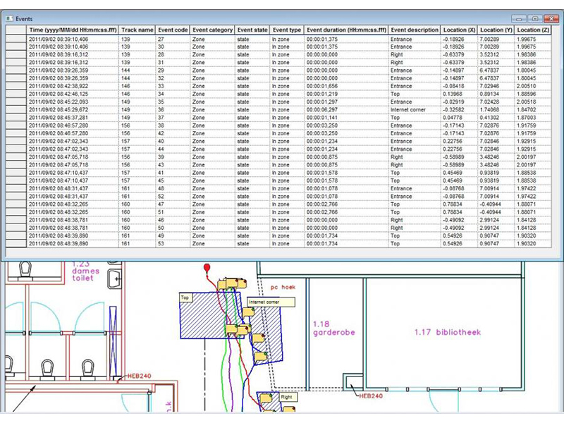
Events related to zone-related behavior or user-defined movement classes can be saved in a log file or sent out in real-time, for example to a smartphone. This real-time feedback allows you to directly gain insight in the location and movement of the test subjects, furthermore it allows you to use this information as input for external applications.
Integrated solutions
Besides TrackLab as a standalone software tool, we can provide you with end-to-end solutions based on TrackLab. By doing this you do not have to worry about compatibility of components or about the installation of the system. After installation of the system you will be trained in how to use the software, enabling you to optimally benefit from the TrackLab setup.
Collecting data
Collecting location and movement data can be done in numerous ways. Every study and every application requires varying technical solutions. TrackLab is a flexible software tool that can handle input from different tracking technologies:
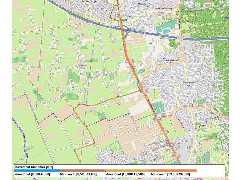
- Outdoor Outdoor tracking can be done in urban environments, agricultural fields or in nature. The most common tracking method for outdoor studies is GPS, although other tracking systems can be used as well. TrackLab supports any type of GPS receiver, taking advantage of data augmentation services (such as WAAS, PPS or EGNOS) if available. These systems offer you real-time or off-line information on the location and movement of your test subjects.
- Indoor Indoor tracking can be applied in settings ranging from a controlled laboratory to a real-life environment, from consumers in a supermarket to cattle in a farm. TrackLab supports a wide variety of indoor tracking solutions, including Ubisense ultra-wideband sensors and tags, EagleEye stereo cameras, the EthoVision® video tracking system, WiFi tracking, and our vision-based PeopleTracker (coming soon). Functionality differs strongly between tracking systems; some systems need tags or markers while others do not, some systems work real-time while others work off-line.
If you are using live data input, you can start a new track using a remote control app on a tablet. This makes it possible to work with the system semi-automatically, so that during an experiment it is not necessary to have anyone next to the computer.
Importing and visualizing data
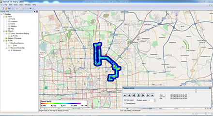
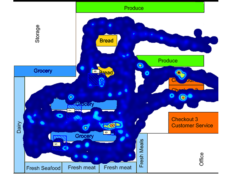
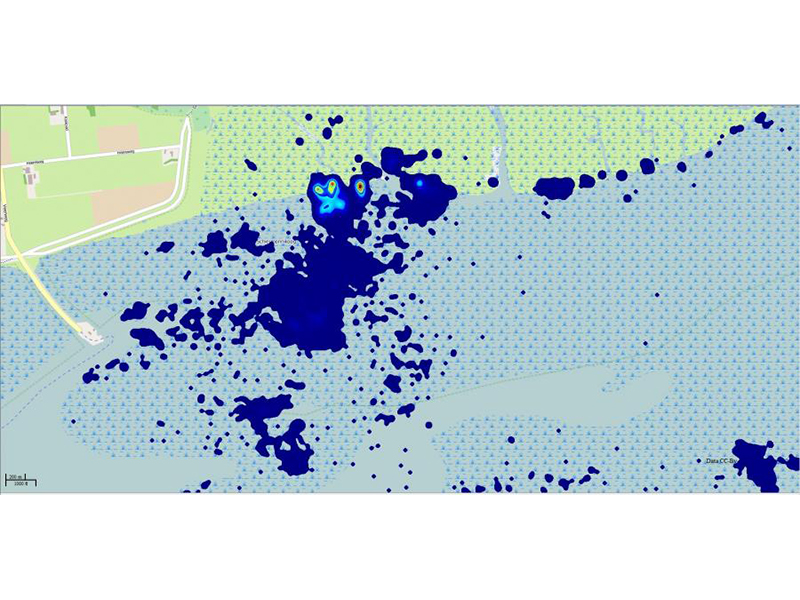
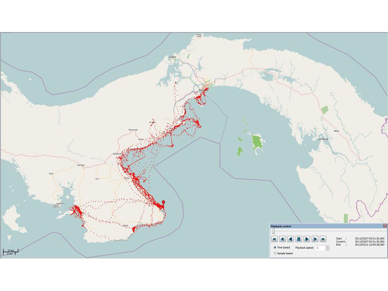
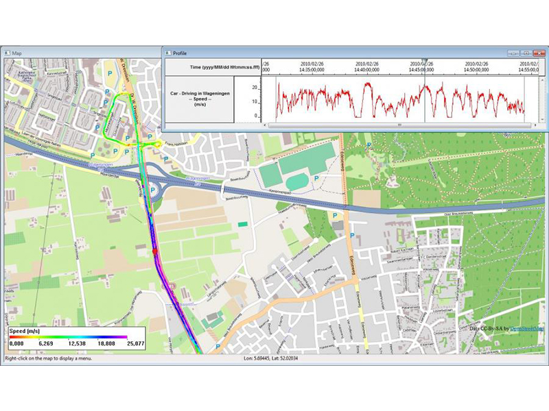
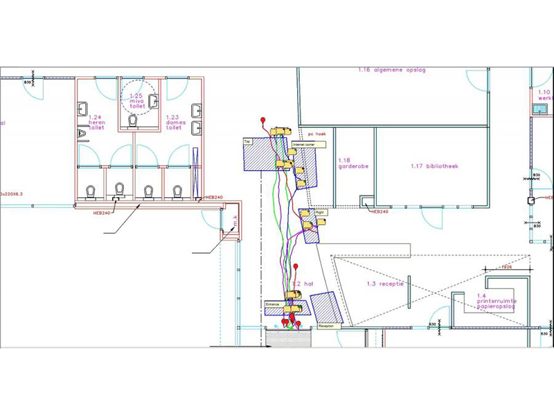
TrackLab allows you to import location data in real-time and offline, depending on the tracking technology and the layout of your data. Once data has been collected, tracks can be visualized on a map within the software, both bitmaps (e.g. floor plan of a building) and geographical maps (OpenStreetMap). The software allows you to visualize tracks of multiple objects simultaneously. Visualizations include various trajectory styles and heatmaps. Furthermore the software offers track smoothing and can automatically remove outliers, improving the quality and reliability of your data. In addition to importing location data, TrackLab can also import and visualize all sorts of external data such as accelerometer data or manually-scored events.
Analysis
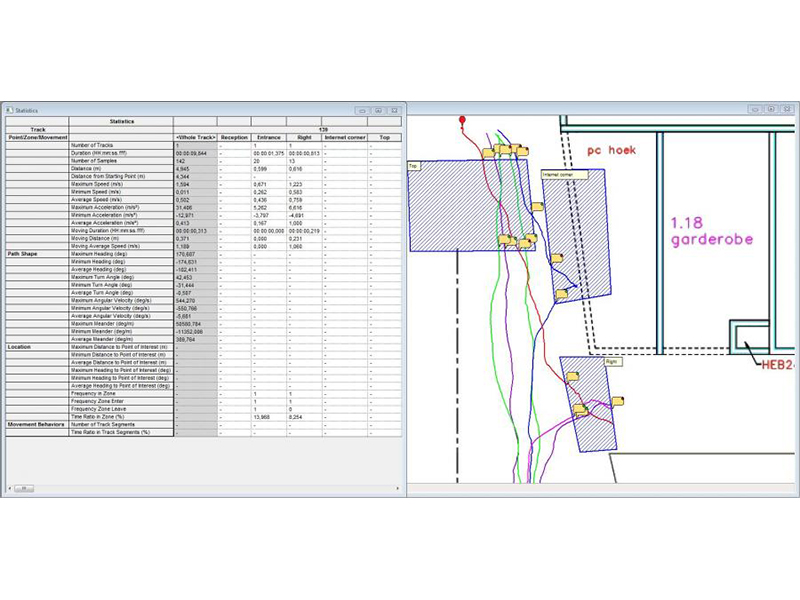
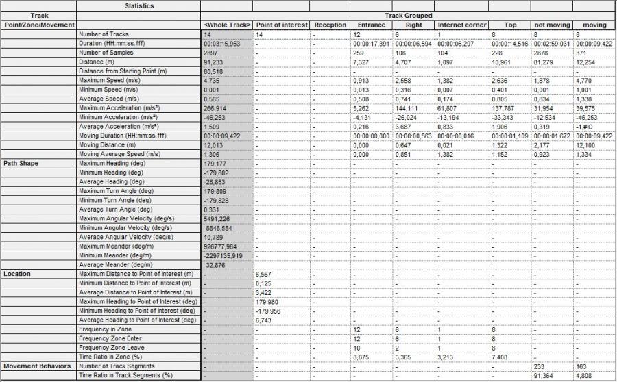
TrackLab provides you with a range of relevant statistics for analysis of location and movement, including various speed and distance variables. Statistics can be calculated for complete tracks or for specific zones or movement classes. The analysis parameters include distance and time (distance moved, speed), location (time in zone, distance to point), path shape (heading, turn angle, meander) and movement behavior (speed based classification).
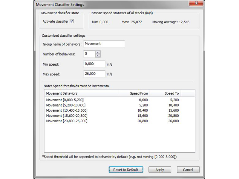
Within TrackLab you can define regions of interest, to compute zone-related statistics or to automatically detect when a subject enters or leaves a specific zone. Besides detecting spatial events movement classifiers can be defined, e.g. to automatically label behavior as standing still, walking and running based upon the speed of the subject.
If you create zones, you can calculate all the statistics for whilst subjects were in the zone. For instance, how fast was the shopper moving when he was in front of the bakery counter? Or what was the meander of the horse whilst it was fora-ging? You can also create intervals according to a variety of other criteria.